


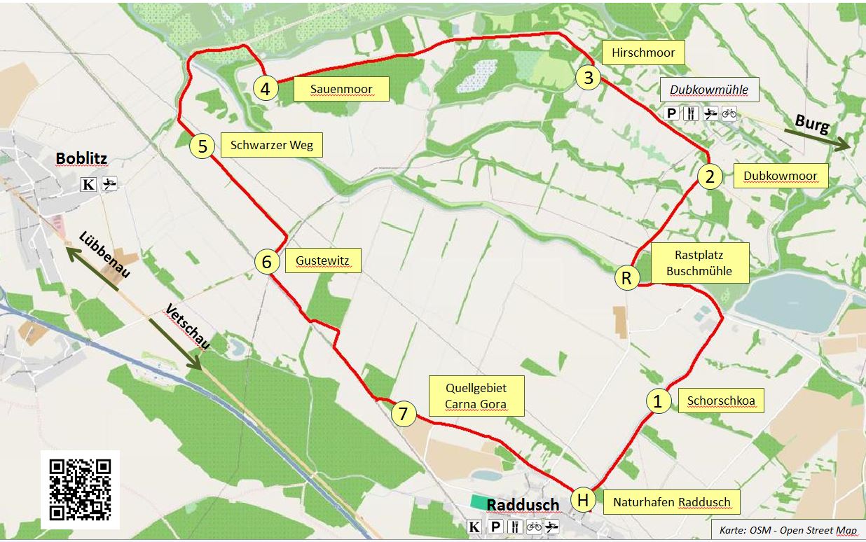
Station 1: Schroschkoa
Audioguide Station 1
Fens and Raised Bogs
As peat accumulates, a bog is developed, typically in the form of a fen. Fens are fed mainly by mineral-rich ground- and surface water. As the layer of peat grows upward over time, it loses contact with the groundwater—and consequently also the nutrients found therein—and must rely on nutrient-poor rainwater for saturation. Such bogs are referred to as raised bogs. In regions of high altitude far from groundwater sources, this process of raised bog formation can also occur without the intermediate stage of a fen, by way of water accumulation in depressions and hollows. Examples of this can be found in the "Krausnicker-Bergen" of the Unterspreewald, located between the towns of Krausnick, Köthen, and Groß Wasserberg.
To classify fens based on their genesis, scientists differentiate between hydrogenetic bog-types, for example spring-, siltation-, or flood-bogs. Fens differ in their water regimes; in other words, through their local hydrological conditions such as the type and frequency of water supply.
Origin of the Fen Landscapes in the Oberspreewald
The formation of the fens in the Oberspreewald begins with the thawing of the northern inland glacier of the last ice age, the Weichselian Ice Age. At its maximum 20,000 years ago, this glacier covered an area that reached all the way to the northern edge of the Oberspreewald.
Formation of a Sandy Inland Delta
The meltwater of the receding inland glacier which was freed after it had reached its maximum extent, created a wide valley– the so-called Baruth glacial valley—as it drained to the northwest. The Spree, coming from the south, washed large masses of sand into this valley when it broke through the terminal moraine, creating a sandy terraced plain with a gradient of only 10-20 centimeters per kilometer. Because of such a low slope to the land, the Spree traveled very slowly and divided into numerous branches, which in turn divided again and formed a common floodplain.
Bog Formation in the Post-Glacial Period
During the post-glacial period, which started about 10,000 years ago, the rising groundwater level and damming-effect of the slow-moving and frequent Spree floods caused large areas of the Spreewald floodplain to become boggy. Organic matter was transformed into peat by this periodic flooding and gradually accumulated over the sandy subsoil. It took thousands of years for the bogs in the Spreewald to develop a shallow peat cover of 0.3-1.0 meters deep. Reeds, alders, and sedges were all typical peat-building plants. The shallower peat thicknesses at specific locations are due to the dry periods between flooding phases, which resulted in peat degradation and stagnant peat accumulation.
The Spreewald Typical "Klockschicht"
The so-called "Klockschicht" is typical of the fen soils in the Spreewald and occurs at many locations. This is a dark-colored soil layer consisting of clay and humus, found under the peat layer, which acts as a water barrier. This layer ensures that flood water cannot drain away and stays on the surface for a long time. Under the Klockschicht lie water-permeable valley sands. If the Klockschicht is destroyed, the water will then sink through the sand due to its large pore size.
On the way to Station 2 after crossing the Südumfluter at the Buschmühle, you enter the "southern diked area" and are now in the nature preserve. Pay attention to the stone barriers at the Krummen Dam River (right side). You can shorten your route along the nature trail at the Buschmühle.
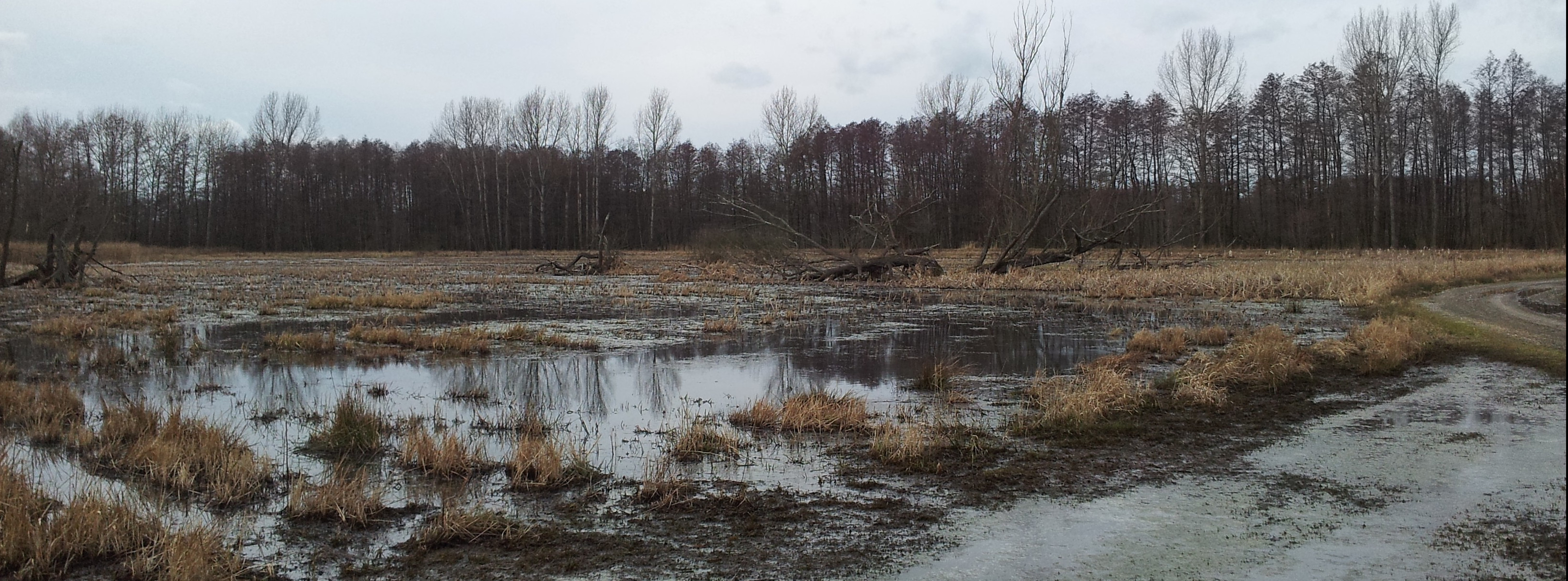
Station 2: Dubkowmoor
Audioguide Station 2
Importance and Functions of Bogs
Intact bogs fulfill many diverse ecological functions within a landscape and also provide a variety of important ecosystem services for people. These functions became well-established over thousands of years beginning with the melting of the inland glacial ice sheet. The most important functions and services of bogs are presented below:
Bogs as Peat-Building Climate Protectors
Bogs are underappreciated climate protectors. The plants that grow in bogs absorb carbon dioxide from the atmosphere in order to grow. Peat is created from the organic remains of dead plants and is able to fix and store carbon. Through this process bogs have been able to store massive amounts of carbon over thousands of years. Therefore, growing bogs are also considered CO2-sinks. And even though bogs only make up about 3% of the global land surface, they store around 450-500 gigatons of carbon worldwide. That is about double the carbon stocks of forests globally and corresponds to about 30% of the earth's carbon!
The average carbon stores of a natural bog vary from 550-2,000 gigatons of carbon per hectare depending on its hydrogenetic make-up and its thickness. The Dubkow Bog has a thickness of up to 3 meters deep and therefore is especially climate-friendly.
If bogs are damaged—for example, through man-made drainage—air gets into the body of the bog and causes the peat to mineralize. This mineralization process causes the carbon that had been trapped in the bog for thousands of years to oxidize and then be released as climate-damaging CO2. As a result of both human influences and natural processes, the greenhouse gases methane and nitrous oxide also play major roles in the degradation of peat landscapes.
Bogs as Water-Saving Sponges
Bogs act much like sponges, thanks to the peat within: during periods of excess water, such as after heavy rains or during floods, it soaks up large volumes of water in a short amount of time. In later dry phases, the stored water is slowly released into the environment in the form of vapor. Bogs therefore create a specific climate that becomes a habitat for many special animal and plant species. If you step on a saturated bog, it will begin to swing and seep water the way a wet sponge would.
Bogs as Habitats for Specialists
Near-natural bogs are irreplaceable components of the biodiversity of landscapes, even though they only make up a small percentage of the land cover today. Bogs serve a variety of highly-specialized plant and animal communities; these communities have evolved over thousands of years within the bog landscape and cannot survive outside of it.
Bogs as Important Water Filters
Bogs are vital water filters and serve important roles in groundwater recharge. Unbound nutrients and pollutants in the water are absorbed by bog plants and are locked away during the formation of peat; therefore, not only are they removed from the material cycle, but the water is also purified.
Bogs as Places for Recreation and Experiencing Nature
Bogs play an important role as "wilderness areas" for experiencing nature and for recreation.
Bogs: Archives of Landscape- and Cultural History
Bogs act as climate, vegetation, and cultural archives because they have been conserving various types of organic matter for 10,000 years. Scientists examine this matter in order to gain insight about the past environmental conditions and the extent of human influence on the landscape over the course of history. For example, archaeological dating methods and the analysis of pollen samples can be used to determine the plant composition of the bogs and their surroundings in the past.
Bogs as Raw Material Deposits
To this day, the importance of peat as a raw material for extraction has not been lost. Peat has been, and still is, used to generate heat and electricity in some countries. It is also used in horticulture as a fertilizer, as well as in medicine and cosmetics.
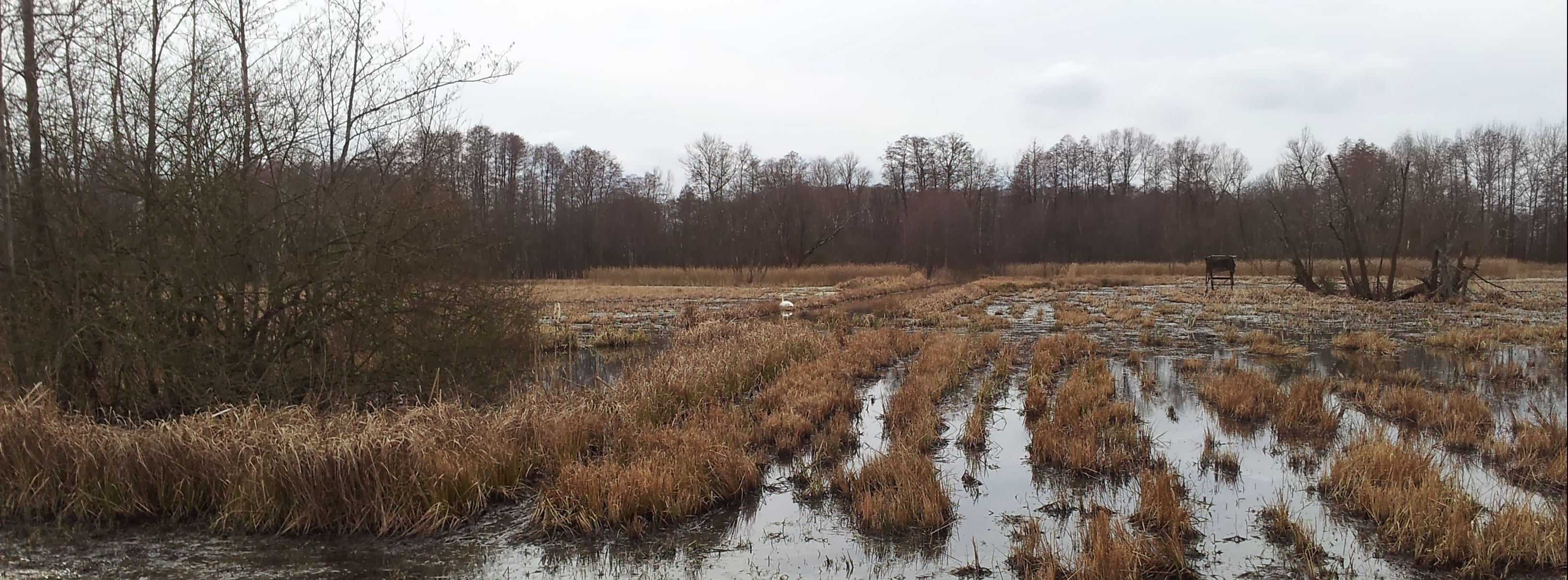
Station 3: Hirschmoor
Audioguide Station 3
Plants and Animals in the Fens:
Fens
Fens are ecologically and hydrologically diverse; their various types of water and nutrient supplies support diverse communities. The acidity of the water and the availability of nutrients determines which species will be living in those respective areas.
Large areas of the Spreewald are vital and irreplaceable habitats for many plants and animals that are adapted to perpetually wet conditions. Many species can only live in these types of habitats because they are tied to the water either temporarily or year-round. The southern diked area, which is now designated as a nature preserve, is particularly special because it serves as a species-rich refuge.
Characteristic Flora and Fauna
In the southern diked area you will find many typical bog species. The fire-bellied toad, along with many other amphibians, calls the Spreewald home. Small stands of cotton grass can be spotted at the beginning of summer, and swamp cinquefoil—which has its largest contiguous distribution within the Spreewald here in the southern diked area—blooms inconspicuously along the way.
In addition, irises, sedges, and different grasses grow in the bog meadows, all of which attract butterflies and dragonflies like the Great Copper Butterfly and the Greater Moss Damsel. In contrast, within the alluvial forests you will find mostly black alders, with a few birches dotted here and there. Marsh marigolds and sweet flag (calamus) sprout up between the trees. Gray willows and reeds overtake the wet meadow areas which have not been cultivated in many years. Many meadow birds that use the area for nesting and rest, such as lapwings, snipes, corn crakes, and cranes, are all natives here. Last but not least, you may spot not only the white stork, but possibly even the extremely shy black stork, which uses its long beak to poke around the wet meadows of the southern diked area for marsh crickets, moor frogs, or mosquitoes. With a bit of luck, you might spot an otter at dusk in this seldom-visited and secluded area of the Spreewald; but you're more likely to see wild boar, roe deer, or Hirsche (relatives of the moose), which come to mate in late summer.
Which species did you discover along your way through the bog landscape?
Bogs: Endangered Habitats
Due to human influences such as irrigation measures and agricultural practices, it is estimated that only about 3,000 hectares of a former 300,000 hectares (~1%) of bog land within Brandenburg can still be considered near-natural and intact (in this case, the term "near-natural" merely indicates that the bogs have been altered over the years by human impacts). This means that only a small fraction of bogs is able to accumulate and grow organic matter in the form of peat.
The steep recession of natural bogs means that the populations of bog plants and animals will be reduced to small communities due to their strong dependence on their habitat. Rare and threatened species, such as swamp cinquefoil, the fire-bellied toad, or the fen orchid, are especially at risk. The remaining near-natural bog areas, almost all of which lie within protected areas like the Spreewald Biosphere Reserve, play a role as habitat for a variety of specialized species. Only through special management practices that connect land usage and nature protection will these areas be maintained for the future.
Station 4: Sauenmoor
Audioguide Station 4
Human Interference in the Water Budget of the Spreewald Bogs up until the 1990s:
Mastering Water for Cultural Advancement
The fen areas of the Spreewald have been used by humans for several centuries. Because of the tight networks of rivers, canals, and ditches, the residents have always been closely connected to the water, both a life-supporting and destructive force. Floods were very common: they could be expected almost every year, and at any time of year. During dry seasons, on the other hand, the low water levels affected boat traffic and sometimes stopped it altogether. Both extremes had negative effects on the agricultural yields and were accompanied by hardship and misery, such as hunger and disease, among the population of the Spreewald. Mastering the water was therefore seen as necessary in order to develop their home and increase their standard of living.
Influences in the First Half of the 20th Century
Massive impacts on the Spreewald water budget began in the 20th century with interventions that made agricultural intensification possible. Frequently flooded areas were diked, pump stations and floodplains were built, watercourses were straightened, and the most important ones were expanded and deepened. A complete water management system was built across the main flow direction of the Spree in the 1930s, with over 100 weirs and dams.
The extent of the intervention was noticeable: the dikes prevented many areas from being regularly flooded. The water was now diverted around the core area of the Spreewald and quickly drained away. The pumping stations and damming system enabled more control of the water levels throughout the Spreewald. Additionally, the grade and flow-rate of the water increased as streams were straightened and their flow-length shortened. Large volumes of water discharge now had more power and speed, which resulted in increased erosion of the river beds and the flows cutting deeper into the terrain.
This ultimately led to groundwater levels dropping dramatically in many areas, in some cases up to two meters. As a result, large areas of the bog landscape were drained and became usable as arable land. These types of hydrological engineering measures were necessary prerequisites to ensure the economic livelihoods of 20th century Spreewald farmers. For the first time it was now possible to use modern technology on the drained areas in the often-flooded Spreewald instead of traditional management methods. Of the 50,000 hectares of floodplain, only 5,000 remained. At the same time, the construction of dikes and floodplains improved flood protection for the settlements.
Impacts of the GDR Era
The advancement of mechanized agriculture in the first half of the 20th century was moderate in comparison to the 1960s: The depth of the pumping stations and drainage ditches were increased from 0.6 meters below ground level to 1.20-1.60 meters, such that the water levels continued to drop. The so-called "Enhancements" of the 1960s and 1970s to increase agricultural and forestry yields were also designed in this sense. These included further technical measures to improve the soil drainage and the embankment of various areas which drained even more of the bog landscape. Perfect mastery of the water was the ultimate goal!
Through the course of the "Enhancements," the approximately 510 hectare "southern diked area" was created which is where you currently stand on the Sauenmoor (see photo on title page). This was one of the last areas in the Spreewald to be drained for the purpose of intensive agricultural use in the 1970s. A dike was constructed around the perimeter of this area which effectively cut-off and drained the Krummes Wehrfließ, Mingoa, Roggozoa, and Krepola rivers. Thus, the land inside the dike became isolated from the rest of the Spreewald and the water levels could be artificially controlled and pumped through the Boblitzer pumping station. In other words, the water levels of this area became effectively lower than those of the surrounding Spreewald. In spite of the improvements, agricultural yields in the very low-lying areas of the Spreewald remained insufficient. Thus, the massive interventions in the ecosystem were already highly-controversial at the time of implementation.
Last but not least, mining during the GDR era had a large impact on the water budget of the Spreewald. This is because large amounts of groundwater were pumped out of the Spree in order to drain the lignite mines, which caused groundwater levels to drop further (more information at Station 7).
Effects of the Interventions
The interventions in the water supply of the Spreewald had an enormous effect on the bogs. The blocking of natural floodplains through dikes, the drainage of floodwater from the floodplains, and the decades of operation of pumping stations resulted in the worsening condition of bog soils because the natural flooding of the bogs—which delivered nutrients to the soil—no longer occurred. Peat formation stopped in many places due to the lack of water: as a consequence of the lowered water table, oxygen was able to reach the top layers of peat leading to its degradation by microorganisms and mineralization. Thus, the water-depleted bog soils were strongly, sometimes irreversibly, damaged. It is confirmed that peat losses of up to 50cm occurred due to subsidence.
As a consequence, many areas are developing soils with insufficient nutrient and carbon contents. The low mass of peat limits the buffering capacity of the bog soils, such that less water is held within the soil during times of flooding. This can result in drought events and vegetation diebacks due to the lack of water in the dry seasons.
During peat degradation, large amounts of carbon, nutrients, and pollution—which have been stored in the peat for thousands of years—are released. The carbon is oxidized to CO2, such that bogs suddenly become carbon sources instead of carbon sinks and further contribute to global warming and climate change. Nutrients like phosphorus and nitrate are often washed out of the soil and can increase the nutrient content of nearby water bodies. As a result, plants that are adapted to high-nutrient soils become more suitable to these environments and slowly replace the specialized species which are adapted to peat soils. Without the implementation of conservation concepts and permanent management, the character of the Spreewald landscape will be lost to the detriment of both humans and nature.
On the way to Station 5 you will leave the southern diked area when you pass the Boblitzer Kahnfahrt. A little further along, if you cross the Südumfluter, you can see the disused Boblitzer pumping station and the flood protection dike.
Station 5: Schwarzer Weg
Audioguide Station 5
Protection of the Spreewald Bogs:
Bogs in Recovery
Starting in the 1990s the water budget of the Spreewald bogs gradually recovered after years of heavy regulation and interventions during the 20th century. This occurred as lignite mines in the neighboring regions were closed, as were pumping stations, such that the groundwater levels slowly rose and the natural water budget of the bogs was re-established. This development was supported by the founding of the Spreewald Biosphere Reserve in 1990 and the associated designation of many areas as land and nature protection zones.
Extensive Management of Rewetted Bogs
With the increase in groundwater level, many areas have become flooded again and are therefore difficult to manage. If the ground is not too wet and can bear the heavy machinery, then 1-2 hay harvests can be expected per year. The mowing occurs in late summer such that meadow birds like the crane can nest undisturbed. The hay is mostly used as feed for cattle or more recently as biomass for energy production at the Göritz Agriculture Company, just 5km away.
In years with low precipitation, the grasslands can be used as pastures. Due to the low yields and heavy use, management of the Spreewald Biosphere reserve is subsidized with funds from the European Union and the State of Brandenburg. Economic use of some rewetted areas is impossible; therefore, such areas are managed solely to maintain the cultural and natural landscape of the Spreewald.
The increased groundwater level in conjunction with extensive usage and landscape management has ensured that the character of the Spreewald bog landscape is maintained and that bog-typical animal and plant species—such as alders, rushes, and reeds—can become dominant again. Peat mineralization has also stopped in many places and peat formation stimulated so that the bogs are now slowly growing at specific locations at a rate of 0.5-1cm per year and thus contributing to climate protection. Today, the primary goal is to keep the water level in the Spreewald bogs high enough such that both land cultivation and peat formation are possible.
Waterfront Strip Project
From 2001-2014, the Waterfront Strip Project made a special contribution to the protection of bogs. A core goal of the project was to raise and stabilize the water-level in the southern diked area in order to stop the ongoing depletion of peat. Two initiatives from this program are outlined below:
Artificial Winter Flooding Areas:
Several streams that had been separated from the surrounding water system when the dike was built were reconnected to the main river. In the winter, all dam structures are opened such that large parts of the diked area are flooded. This unlimited flow is only possible in the winter. The "Enhancements" of the 60s and 70s so effectively shrank the body of peat that if unlimited water flooded into this area in the summer as it does in the winter, the fields would be too wet for the typical Spreewald management and cultivation to occur. Therefore, in the summer only a limited amount of water– in accordance with the current conditions of low precipitation—is let into the area through a single inflow source. Thanks to the improved water supply in the summer and flooding in winter, the fluctuations in groundwater levels between summer and winter have been significantly reduced. Additionally, former extreme lows in water level have risen by up to 60cm in the summer months.
Installation of a Stone Barrier:
A stone barrier was built across the Krummen Dam River such that the water level was raised in the higher eastern part of the southern diked area. This allowed for the area to be ecologically improved.
Bog Conservation on the Small-Scale: How can you protect bogs?
There is much to do in order to preserve and protect the bogs here in the Spreewald and throughout Germany. That's where YOU come in! Because even small actions can have big impacts and contribute to the protection of bogs. You can find some simple examples here:
• Peat-Free Gardening: Avoid buying peat-based potting soil. Peat is continually mined in large amounts to enrich potting soil, even though there are many good alternatives such as compost, bark humus, or wood fiber.
• Leave Bogs Undisturbed: When visiting a bog, follow the designated routes, especially if it is in a nature preserve. Most importantly, leave the bog as you found it.
• Be Active!: There are many initiatives and associations in which you can take part in a variety of ways to protect bogs, such as the Naturschutzbund (NABU) or the Brandenburg Naturschutzfonds Foundation.
• Share Information about Bogs: Tell your friends and acquaintances about the Multimedia Bog Nature Trail and what you've learned about bogs.
• Invest: Consider giving money to projects that support the protection of bogs.
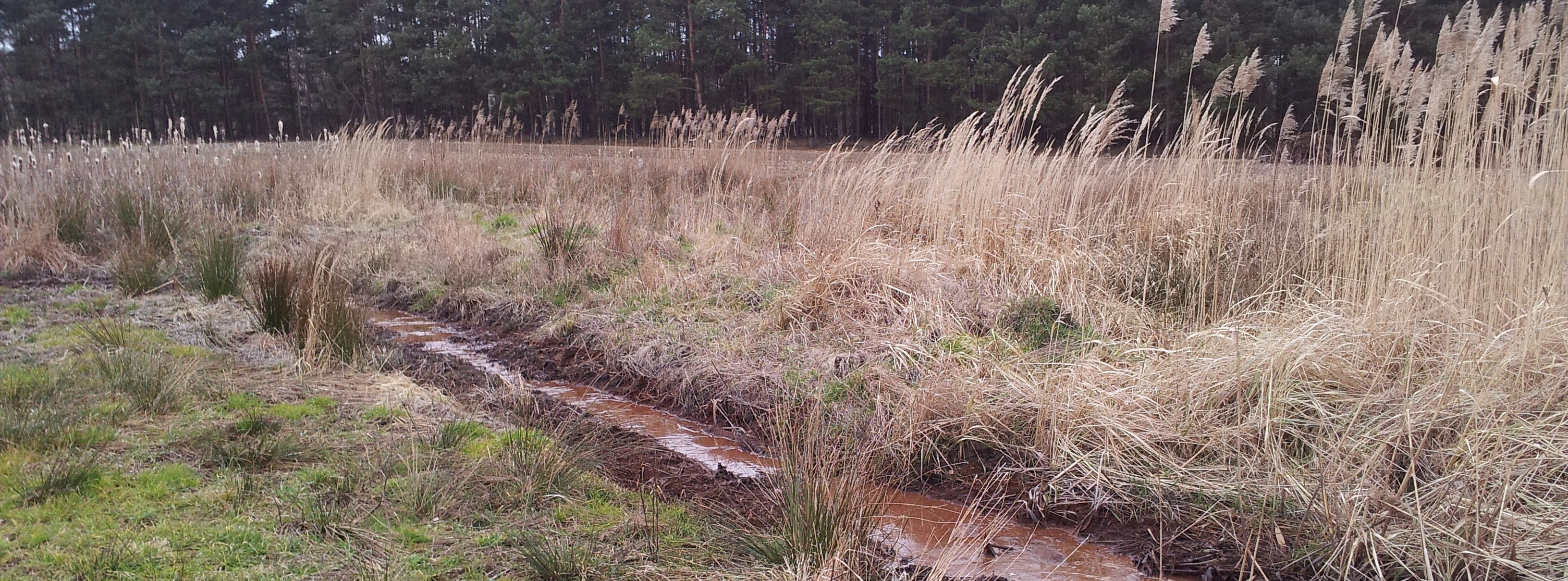
Station 6: Gustewitz
Audioguide Station 6
Peat Depletion in the Spreewald
"Am Torfstich" is still a commonly used designation in the Spreewald to mark where peat was manually cut from the bogs. Today, however, only the oldest residents know about its origins because peat cutting as a practice has largely been forgotten. In the Oberspreewald in particular, so-called "peat cutting" bogs developed in many areas although they are now difficult to identify since in some cases more than a century has passed since peat removal.
19th Century
The beginning of the 19th century marked the start of peat extraction in the Spreewald for burning fuel. This was due to the wood shortage caused by forest clearing for meadow areas and the establishment of settlements. Up until the middle of the century, burning peat was a part of everyday life. In the southern part of the Oberspreewald there were many cooperatives for manual peat cutting. Towards the end of the 19th century, cheaper lignite gradually replaced peat as fuel.
Peat Extraction after World War I
Coal was scarce in the Spreewald after the first World War due to the specific reparations and cession of land in the Treaty of Versailles which led to the loss of coal fields. As a result of coal scarcity in the 1920s, people returned to burning peat for fuel. Peat cutting- and mixing machines were also used for peat extraction. In Raddusch, peat mining continued up until 1924.
Peat-Extraction in the GDR Era
The interest in organic raw materials surfaced again during the GDR era, especially in the 1980s. During this time peat was extracted for use as fertilizer for agriculture and only wheeled excavators were used. The extraction sites were mainly on the outskirts or outside of the actual Spreewald lowlands. The peat cuttings during the GDR-era were significantly deeper and larger than those of the 19th and early 20th centuries.
The Day-to-Day Process of Manual Peat Cutting
The day-to-day process of peat cutting, in which peat was extracted by hand, took place in the Spreewald as follows:
"A ditch was dug by hand to drain the area and clay pipes were laid on the bottom to drain the water. Five workers were needed to cut the peat. The first worker, known as the "Abbanker" removed the top, mostly unvalued, layer of plants and peat. A second worker, called the "Stichler," took over the actual cutting of pieces of peat (called sods or peat-bricks) with a sharp peat spade called a graver. The third worker took the peat-bricks and threw them out of the ground, where they were carried away by a fourth worker. A fifth worker removed the quickly-refilling water from the ditch. After transport, the peat-bricks were finally stacked in the farmyard to dry. Instead of extracting peat from all over the bogs, workers laid out rectangular, side-by-side ditches with peat banks in between them."
You can find more information on peat extraction and historical equipment at the Radduscher Heimatstube.
Station 7: Source Area Carna Gora
Audioguide Station 7
Influences of the Lausitz Lignite Mines on the Spreewald Bogs
The lignite mines in the Lausitz area had and still have a large influence on the Spreewald bogs. The former pit mines of Schlabendorf-Nord and Süd, as well as Seese-West and Ost—which have now been re-cultivated—are located directly southwest of Raddusch. Lignite was mined there at various times between 1959 and 1996.
Water Budget During the Coal Mining Era
In order for mining to take place, the ground water level had to be lowered. Therefore, water was pumped out of the mines and into the Spree which almost doubled its natural volume of water. These measures resulted in a funneling effect that reached into the southern area of the Spreewald lowlands and caused the groundwater levels to drop significantly. The lower groundwater levels resulted in uneven subsidence of the terrain in the areas between bogs and sandy soils. While bog peat oxidized and shrank up to 60cm, the sandy soils hardly shrank at all. These unequal changes in terrain height led to the damage of many buildings, especially in Raddusch.
Groundwater Resurgence after Coal Mining
After the Lausitzer lignite mines were closed and re-cultivated in the 1990s, the groundwater levels began to rise and the funnel that had been created filled with water again. However, the combination of Spree waters being diverted to fill the pit mines to form lakes, along with the absence of mining wastewater influx, resulted in the water level of the Spree sinking dramatically. Up until around 2010, the flow rate of the Spree was even lower than before coal mining times. In the following years the original groundwater levels were restored. At Black Mountain ("Carna Gora" in the Lower Sorbian language) the groundwater levels have risen again: for a few years it has been an active spring once more. The source water flows off the hillside and into the adjacent lowland (not visible during dry periods), leading to the rewetting of bog soils and meadows. This is what protects the bogs and meadows and prevents their degradation.
The Phenomenon of Iron Hydroxide Deposition
An ecological problem is apparent here at the spring Carna Gora that has concerned Spreewald residents for some time: the spring water quickly turns brown and murky when exposed to the air. The cause of this phenomenon is the process of iron hydroxide deposition.
Rusting of the Spree Waters
As groundwater comes into contact with iron ore in the soil (which occurs in abundance in the Niederlausitz region) iron hydroxide contamination occurs. As the groundwater rises to the surface it comes into contact with oxygen which in turn triggers a chemical reaction: "rust" is formed and creates the typical brown coloration of the water. Due to former mining sites in the southern part of the Spreewald, iron hydroxide deposition is additionally intensified: as groundwater began to rise again, weathering products of pyrite (such as iron hyrdoxides and sulfates) that had formed during mining operations when the groundwater levels were low, were washed out of the open pit mines and entered the Spree and its southern tributaries.
Effects on Flora and Fauna
In the southern tributaries an obvious discoloration of the water has been observed since 2010. Since then the brown water has also reached the outskirts of the Oberspreewald, which is threatening its ecosystems. Although non-toxic itself, iron hydroxide deposition leads to the death of plants and animals: as the iron particles settle in the water bodies they can clog the respiratory organs of small creatures and fish, as well as create a film covering plants and water beds. Water habitats thus become uninhabitable and fish-eating animal species such as black storks, kingfishers, and otters can no longer find food.
In 2013, the state government on the initiative of the regional action alliance "Clear Spree e.V." based in Lübbenau, decided on an immediate program that was intended to combat iron hydroxide deposition. However, it is still uncertain how well and quickly the measures will take effect. What is certain, though, is that it will likely take years or even decades to handle and adapt to these long-term consequences of mining.
More about Bogs?
Want to know more about bogs? Here you will find a selection of literature sources from which you can learn more about bogs and the Spreewald bog landscape.• Hochschule für Nachhaltige Eberswalde (2011): Steckbriefe Moorsubstrate. >>http://www.mire-substrates.com/<<
• NABU-Bundesverband (2013): Schutz und Entwicklung unserer Moore. Zum Nutzen von Mensch, Natur und Klima. 2. Auflage.
• >>https://ww.nabu.de/imperia/md/content/nabude/naturschutz/moorschutz/moorschutzbrosch__re_auflage2.pdf<<
• Luthardt, Vera & Jutta Zeitz (2018): Moore in Brandenburg und Berlin. 2. Auflage.
• Röver, Anne & Horst Hamm (2014): Spreewald verstehen, schützen & erleben. Einblicke in ein Naturschutzgroßprojekt – unterwegs auf acht Erlebnistouren im Unter- und Oberspreewald.
• http://www.gewässerrandstreifenprojekt-spreewald.de/?page_id=112
Map download
JPG | 172 kB
Flyer download
PDF | 6.3 Mb
